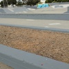
For the Main Street ferry terminal, the City is working on a multimodal solution to improve access as stated in project #6 in the City's Transportation Choices Plan. Later this year, Main Street between Appezzato Pkwy and the Main Street ferrry terminal will be restriped to include bike lanes so as to encourage bicycling. In August 2020, the direct San Francisco ferry service is planned to switch to the Seaplane Lagoon ferry terminal, which is expected to reduce parking demand at the Main Street ferry terminal. City staff is working on a citywide parking management plan, which includes potentially charging for ferry terminal parking so as to raise revenues for parking lot improvements such as resurfacing of the dirt lot and moving the dog park. This work would trigger the need for stormwater and waterfront trail improvements, which also are unfunded but could be funded through parking charges and other grant monies.
While your reply is appreciated, it is also very frustrating because you've raised more questions than answers through your numerous vague references to future plans and options without providing information.
Where is the City's Transportation Choice's Plan publicly available? Project #6? The change in ferry routes? Where and when will be the public comment period for the citywide parking management plan? Why has the City not worked with Google and other mapping services to get the Seaplane Lagoon ferry terminal on map?
The Seaplane Lagoon ferry terminal is under construction so it is not yet shown on existing maps.
The citywide parking management work will be reviewed at a future Transportation Commission meeting either on Nov 20 or Jan 22.
If you would like to discuss any of these planning efforts, please feel free to call me anytime at 510-747-6892 or email me directly at gpayne@alamedaca.gov
5 Comments
City of Alameda (Verified Official)
Mark (Registered User)
クローズド Public Works Transportation Planning (Verified Official)
Reopened Stephen (Registered User)
While your reply is appreciated, it is also very frustrating because you've raised more questions than answers through your numerous vague references to future plans and options without providing information.
Where is the City's Transportation Choice's Plan publicly available? Project #6? The change in ferry routes? Where and when will be the public comment period for the citywide parking management plan? Why has the City not worked with Google and other mapping services to get the Seaplane Lagoon ferry terminal on map?
Public Works Transportation Planning (Verified Official)
The Transportation Choices Plan is available at the below link under "key documents":
https://www.alamedaca.gov/transportation
The Seaplane Lagoon ferry terminal is under construction so it is not yet shown on existing maps.
The citywide parking management work will be reviewed at a future Transportation Commission meeting either on Nov 20 or Jan 22.
If you would like to discuss any of these planning efforts, please feel free to call me anytime at 510-747-6892 or email me directly at gpayne@alamedaca.gov